
CAMPING UPDATE 4/1/26
California State Parks is excited to announce that Limekiln State Park will reopen to camping beginning April 1, 2026. Limekiln State Park has been limited to day-use visitation for over a year due to multiple landslides along Highway 1, which restricted safe public access and limited the ability of park staff to fully operate the campground. Following the reopening of Highway 1 at Regent’s Slide in February 2026, Monterey District staff have been working diligently to restore park operations and prepare the campground for visitors.
Make camping reservations in advance at Reserve California or call 800-444-7275.
With park facilities and utilities now back online and seasonal staffing in place, Limekiln State Park is ready to once again welcome overnight guests. The park will continue to be accessible from 8 a.m. to sunset daily, for Day Use visitors; however, be advised that Day-Use parking is extremely limited inside the park.
About Limekiln State Park
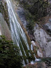
The park features breathtaking views of Monterey Bay National Marine Sanctuary and the rugged Big Sur coastline, in addition to redwood forests and the cultural history of limekilns.
Location-Directions
The park is located two miles south of Lucia off Highway One.
Seasons/Climate/Recommended Clothing
The weather can be changeable. Layered clothing is advised.
Key Information for Visitors:
Limekiln Trail to Pitkins Curve Trail and ocean view overlook is open.
Hare Creek and Limekiln Falls Trail remain closed.
Park Fee Details:
Day-use fees are cash ONLY. $10 per vehicle; allows access to other California State Parks until closing on the day of purchase. Closing times vary by park. There is limited day use available.
Senior discount:Age 62 or older, $1 off, except vehicles over nine passenger capacity.
Disabled Discount Pass Holders: $5
Distinguished Veterans Pass Holders: No charge
Golden Bear Pass Holders: No charge
Limited Use Golden Bear Pass Holders: No charge during off-season (Labor Day through Memorial Day)
State Parks Pass holders must present a pass at the kiosk upon entry to the park. Most State Park passes can be purchased at the Monterey District office at 2211 Garden Road, Monterey, CA 93940. Please visit the pass sales locations webpage to find Monterey District pass sales offices.

