
Partnership with Solano County Resource Conservation District
California State Parks is working in collaboration with the Solano County Resource Conservation District on the Glen Cove Waterfront Enhancement Project. This is a multiyear project that will have minor impacts to park users- temporary area closures, herbicide applications, project days with volunteers, etc.,. The project will benefit local pollinators, wildlife and help to ensure biodiversity within the project area. The project involves removing non-native plants, planting native trees, shrubs, grasses and wildflowers that are culturally significant to the Yocha Dehe Wintun Nation. To learn more about this project, please visit the Solano Resource Conservation District. For questions about the project, please email- info@solanorcd.org.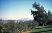
Cyclists, runners, walkers, equestrians, and roller skaters enjoy the park’s 2 1/2 miles of road and bike paths. Picnicking, bird watching and fishing are also attractions. Dogs must be on a leash at all times.
The marshland area on Dillon’s Point is a particularly favorite place for fishing. A parking fee is required.
Three "Enroute" campsites are available for an overnight stay on a "first-come, first-served" basis with no reservations possible. This camping is limited to motorhomes or vehicles with trailers, which must be fully self-contained. Tents are not permitted. Collecting or destroying anything in the park, including mushrooms, is prohibited.
Location - Directions
The recreation area is 1.5 miles west of the outskirts of Benicia on I-780, take the Columbus Parkway exit.
Latitude/Longitude: 38.0780/ -122.1926
Park Specific Rules
Superintendent Orders are laws that are specific to a State Park District and/or a California State Park. The links below will take you to a copy of each District Superintendent Order that applies to Benicia State Recreation Area (SRA). These orders are posted for viewing at each public entrance of the park. These orders are subject to change and were recently renewed in 2026. Benicia SRA is part of the Diablo Range District
Diablo Range District - Trail Use Policy
Diablo Range District - Unmanned Aircraft Systems
Diablo Range District - Juvenile Curfew
Diablo Range District - Camping Limits
Diablo Range District - Rescinded Orders
Seasons/Climate Recommended Clothing
The weather can be changeable; layered clothing is recommended.


